January PNW Snowpack
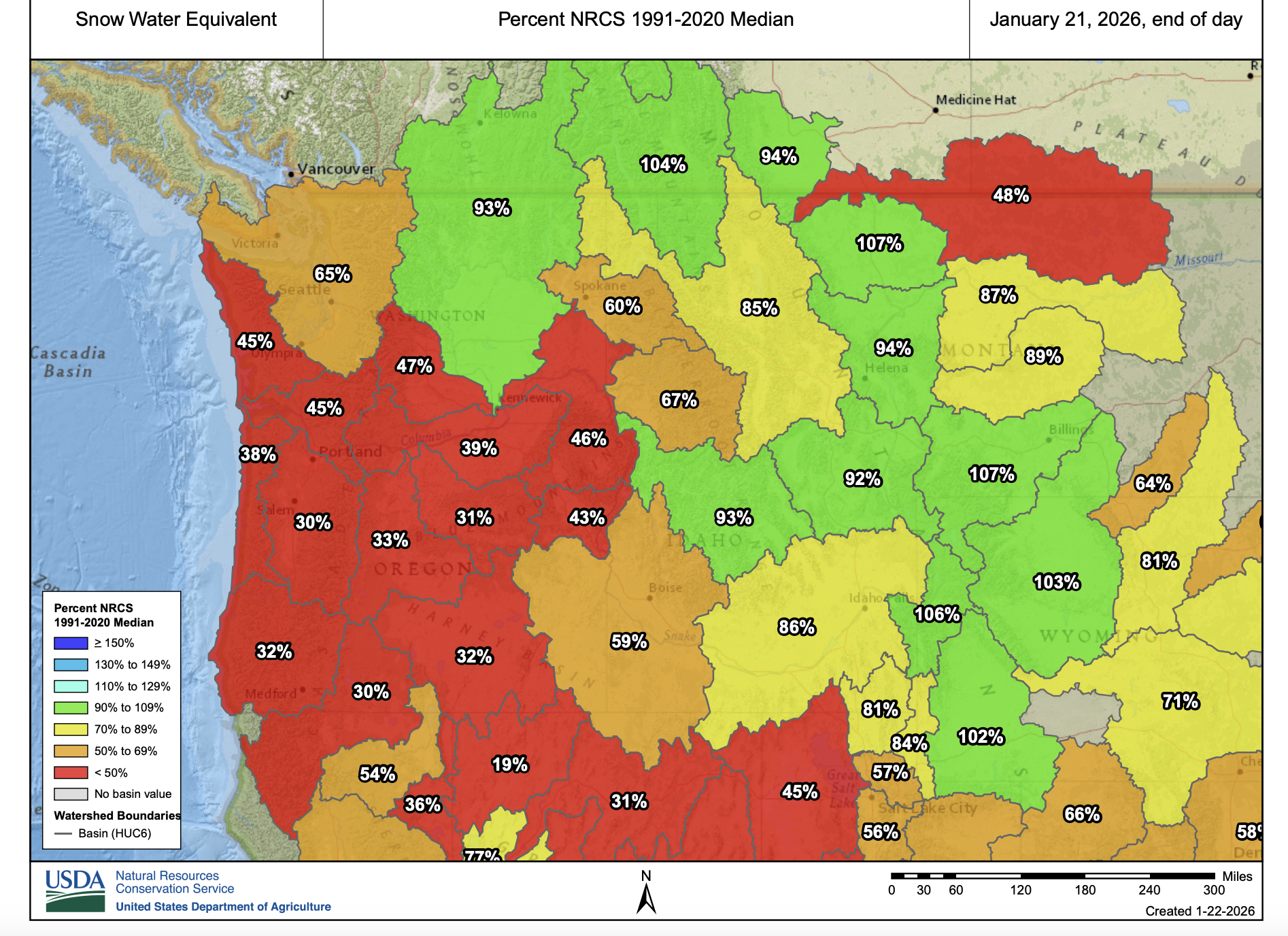
PNW Regional Snowpack 1/22/26 (USDA- https://nwcc-apps.sc.egov.usda.gov/imap/)
We are typically in the middle of winter here in the Pacific Northwest and the snowpack is looking pretty bleak so far. In the basin plot above many of the basins in Washington and Oregon are at really low levels compared with the 30yr median. Montana, parts of Idaho and southern California are positive areas on the map where the snowpack is close to the 30yr median for this date. We still have big snow months of February and March left to go so hopefully things turn for the better here next month.
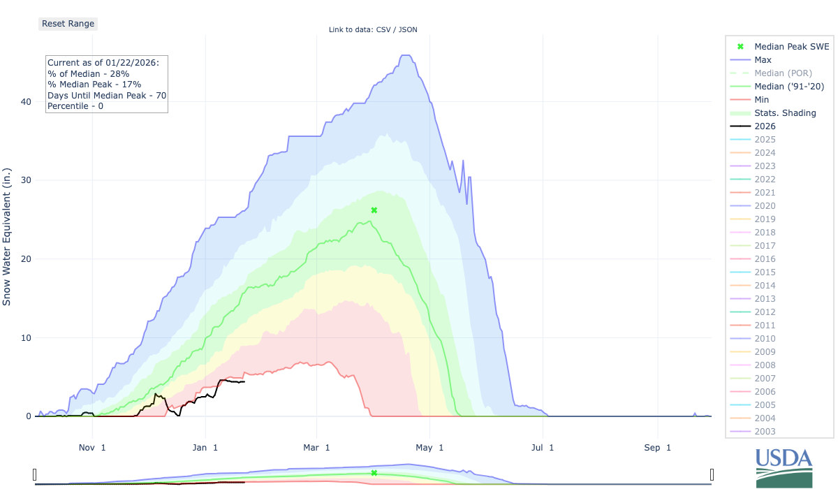
High Ridge Snotel Station Data for Winter ‘25-’26 (1/22/26) (Blue Mtns NE Oregon) USDA
Zooming in a bit to take a look at the snow trend for this winter we can see a few things. I’ll use the High Ridge snotel station for my analysis again (see previous blog posts for previous analysis). Taking a look at the readings you can see that winter tried to get started in early December with some strong snow storms. Unfortunately, soon after that snow fell, it completely melted after a large warmup. This caused widespread flooding in many parts of Washington and caused quite a bit of damage to roads and infrastructure. In the Blue mountains, we finally got another snow storm in early January that helped things out, but the snowpack has flatlined since then with no new accumulations of snow. From the High Ridge snotel chart above you can see that much of this winter has recorded the lowest snowpack on record at the site since 1979. It would be really nice if the second half of winter pushes that trendline well above that lowest on record, but we shall see.
Switching gears a bit to the subject of bikepacking, specifically the XWA bikepacking Grand Depart, let’s take a look at two other snotel sites in the cascade range to see if XWA riders are likely to face any snow on the trail in May. As a reference point, I participated in the XWA in May of 2022. That year had a very cold spring and caused the cascade snowpack to linger well into May. The Snoqualmie pass (Palouse to Cascades) rail-trail tunnel was still closed that year for me and I faced several miles of pushing my bike through snow on the trail.
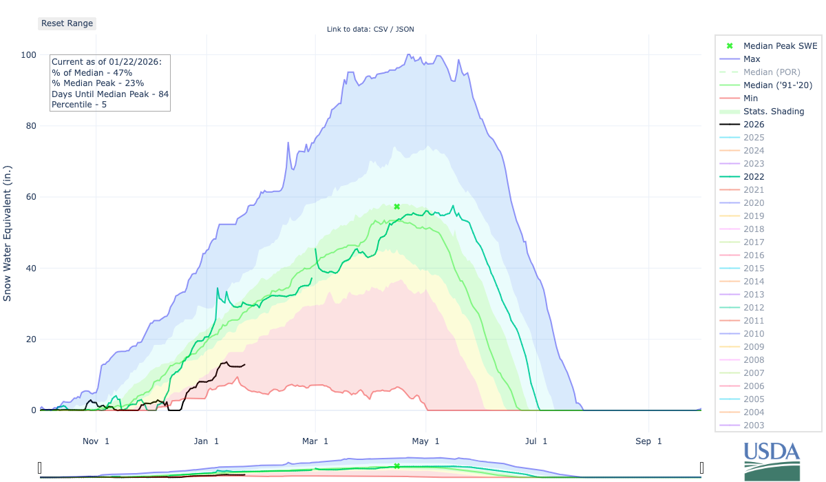
Olallie Meadows Snotel Site Winter of 2022 vs. 2026 - USDA
The Olallie Meadows snotel site is located at 4000ft elevation and is one of the closest snotel stations to the XWA route over Snoqualmie pass. You can see that we are well below that 2022 trendline taking a look at the plot above. As of 1/22/26 the SWE reading is 12.9 versus a reading of 30.1 on the same date in 2022. You can’t really use this data to predict the future, but looking at the trend so far this winter it looks favorable for a snow-free XWA in May.
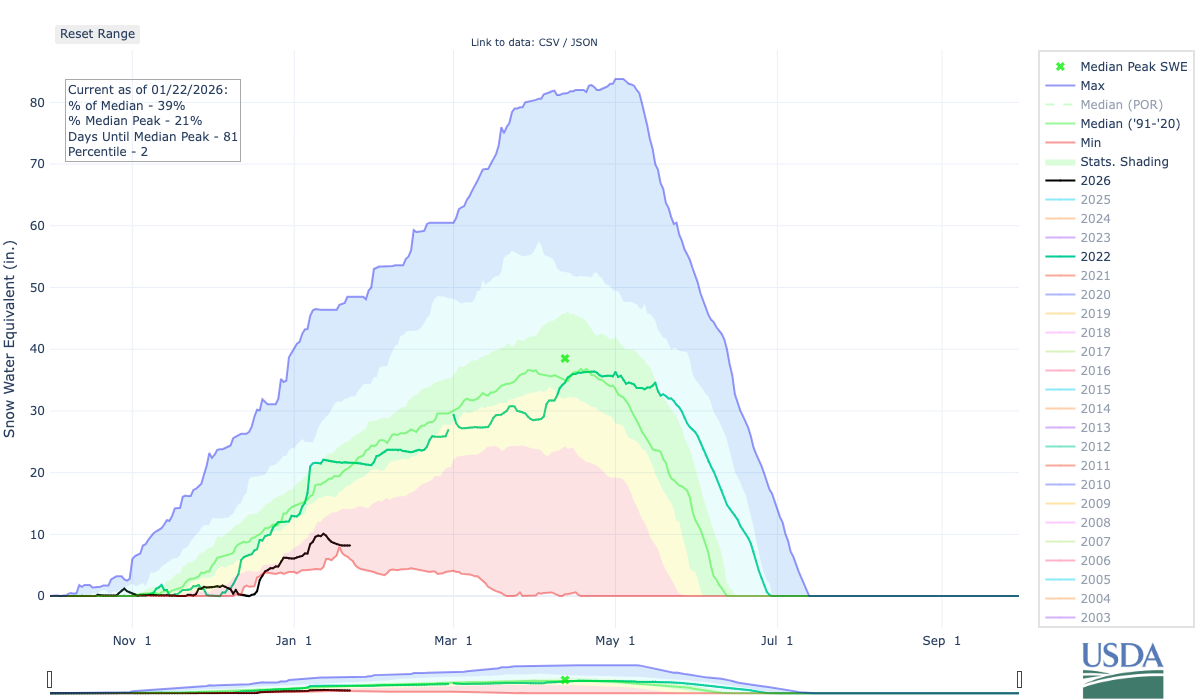
Stampede Pass Snotel Winter of 2022 vs. 2026
Also above is a second snotel site at Stampede Pass (elevation 3850ft). This snotel site is also close to the XWA route and is slightly lower in elevation than the Olallie Meadows snotel site. Again, same trend in 2026 being well below the snowpack levels of 2022.
I guess the main takeaway from this analysis all depends on your perspective. If you are a snow sports enthusiast, farmer, wildland fire fighter, etc. then you are probably not liking the way this winter is shaping up so far. If you are a XWA participant then maybe you like the way things stand. Regardless, I hope you can get outside and enjoy the weather, whatever it brings. Thanks for reading.
If you enjoy this site and want to contribute please consider a donation.